

SALINAS VALLEY — An evacuation shelter has opened at the Salinas Valley Fairgrounds in King City to offer relief to fire evacuees in the region.
Beginning today, the shelter will provide sleeping and meal accommodations for up to 40 residents affected by the River Fire currently burning in the Salinas Valley. Covid-19 protocols are in place at the fairgrounds, 625 Division St.
Evacuees who wish to shelter using their RVs can bring them to the fairgrounds and check in at the shelter, according to a news release from Monterey County.
The shelter will also be able to accommodate pets.
“Due to its long distance from other animal sheltering facilities and because the shelter is located at a site with animal housing available, fairgrounds staff and volunteers worked collaboratively with the SPCA of Monterey County and have supplies and equipment ready to house both pets and larger animals,” the county said.
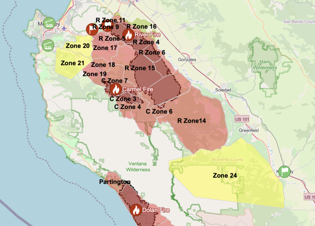
The county expanded its evacuation shelters to South Monterey County due to additional evacuations from the River Fire, which has burned 48,424 acres and destroyed 16 buildings south of Salinas as of Sunday. The fire is currently 15% contained.
Other shelters have been set up at Carmel Middle School, 4380 Carmel Valley Road, Carmel; Sherwood Hall, 940 North Main St., Salinas; and Monterey Conference Center, 1 Portola Plaza, Monterey.
The county also opened an evacuation center at the King City Branch Library, 402 Broadway St., which provides information and support, snacks, water and device charging for evacuees from 8 a.m. to 8 p.m.
The Carmel Fire, which is less than 2 miles away from the River Fire, has burned 6,695 acres and destroyed 32 structures. It is 10% contained as of Sunday.
More than 9,000 residents have been evacuated due to the fires, Cal Fire said.
“The (River Fire) is expected to continue to burn on the southern end of the fire. The wind shift will be the concern on the southern edge, allowing the fire to outgrow the current lines on the southeast portion of the fire,” Cal Fire said Sunday in its latest incident update. “If the fire moves too far south when the winds move to the southeast flow, it could merge into the Carmel Fire.”
Monterey County Sheriff’s Office issued an evacuation warning Saturday night for residents living in Zone 24, west of Greenfield and King City. The area includes Arroyo Seco, Jolon and Pine Canyon roads east of Junipero Serra Peak.
An evacuation warning means those in the specific area should be prepared to evacuate at any time, if a mandatory evacuation order is called.
EVACUATION ORDERS
- Pine Canyon Rd, Parker Rd, Laurel Ln, and Trimble Hill Ln.
- West of River Rd to Parker Rd, South to Limekiln Rd to include Limekiln Rd.
- Southwest of Parker Rd, northwest of Corral De Cielo Rd, and Rana Creek
- West of river Road from Limekiln Rd to Gonzales River Road
- All areas south of Highway 68, east of San Benancio Rd to include San Benancio Rd south to Harper Canyon Rd
- Harper Canyon area, all areas within north of San Benancio Rd, west of Troy Ln, southeast of Harper Canyon Rd, to include Harper Canyon Road, Weather Rock Way, and Rimrock Canyon Rd
- South of River Rd from Tara Dr to Pine Canyon Rd to include all roads off of Las Palmas Pkwy, Ranchito Dr, Indian Springs Rd, Berry Dr, Enos Dr, Redding Dr, and Belmont Circle
- Southeast of the intersection of Chualar River Rd and River Rd, northwest of Limekiln
- All areas south within the intersection of Hwy 68 and River Road to Tara Drive and Hwy 68 south to San Benancio Road, including the Los Palmas 1 and 117 Drive Communities. This order does not include the Toro Regional Main Park area.
- West of River Rd extending west to Carmel Valley Rd
- West of River Rd south from Gonzales River Rd to Puma Rd
- East of Carmel Valley Rd from south of Tassajara Rd to Finch Creek
- All areas from Corral de Tierra Rd and Underwood Rd extending south to Tassajara Rd
- All areas east of Carmel Valley Road extending south from Finch Creek to Arroyo Seco Road. All areas west of River Road/Fort Romie Road/Arroyo Seco Road extending south to Elm Ave/Arroyo Seco Road.
Evacuation Warnings
- Indian Canyon, Mt. Toro Access Rd and San Benancio Rd from Troy Ln. to Corral de Tierra, including Corral del Cielo Rd, Lucie Ln, and Covie Ln
- Areas North of Highway 68 from Portola Drive and Veronica Drive/Estoque Place east, to include all roads off of Portola Drive to Creekside Court.
- All areas east of Carmel Valley Rd extending south from Finch Creek to Arroyo Seco Rd
- All areas west of River Road, Fort Romie Rd, Arroyo Seco Rd extending south to Elm Ave and Arroyo Seco Rd
- Northwest of Limekiln Rd/Creek
- Southeast of the intersection Chualar River Rd, and River Rd
- All areas south of the intersection of East Carmel Valley Road and Arroyo Seco Road to the intersection of Arroyo Seco Road and Elm Avenue, to the intersection of Elm Avenue and Central Avenue.
- All areas west of the intersections of Elm Avenue and Central Avenue south to the intersection of Central Avenue and Highway 101 to the intersection of Highway 101 and Jolon Road to the intersection of Jolon Road and San Lucas Road.
- All areas north from the intersection of Jolon Road and San Lucas Road to Junipero Serra Peak.
- All areas east of Junipero Serra Peak to East Carmel Valley Road.